allows the automatic intersection of overlayed themes and the production of risk maps with the following methodology:
- standardises the themes to intersect and the related polygon codes in database;
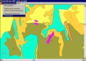
- guides through the choice of project themes;
- enables to choose a theme from a theme table of predefined subject;
- guides to draw on the correct plan with pre-assigned colours;
- enables to choose a centroid value from a centroid table with predefined values/codes stored in database;
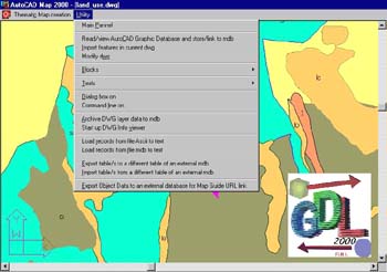
- creates topology;
- exports from the map to an Access table, the value, that characterises the contents of a polygon, with the related area and the assigned ID.
- on request, moves onto layers (named with the value of the centroid and theme prefix) the closed polygons of the topologies to enable you to export in other formats for users of MapGuide, MapInfo, ESRI or for AutoCAD users that need to create hatches on any of the closed areas.
- creates automatically a thematic map with predefined colour (slope maps, geological maps or population maps).
- enables you to overlay more topologies without the limitation of two overlays at a time, and keeps trace of the polygons that have generated the final overlay.
- produces in such a way the Elementary Territorial Units (UTE), that are the areas of the final resulting overlay having the elementary information (i.e. knowing all the values of the polygons that created the overlay). Such a methodology was used, for example, in the Lazio Region to create landslide risk map based on the indexes method.
- Transcribes onto a drawing an identity value, a unique polygon ID, chosen by user, that characterises the related UTE polygon.
In like mode a designer becomes a GIS expert following the lead of questions from the databank. This therefore enables you to print the zoning subdivisions in a plan or the flooding areas of a river or the risk zones as it was always been done by hand, and the data base imposes coded hatches, colours, etc.